
- SpaceX’s Falcon 9 launched two WorldView Legion satellites from Kennedy Space Center, enhancing Maxar Technologies’ satellite fleet.
- The launch occurred at 6:13 p.m. EST, marking SpaceX’s second Falcon 9 mission of the day, highlighting their operational precision and efficiency.
- The rocket’s first stage booster successfully landed at Cape Canaveral’s Landing Zone 1, showcasing its reliability on its fourth flight.
- The new satellites provide a remarkable 30 cm-class resolution, capturing detailed images of three million square kilometers daily.
- Maxar’s constellation now covers 85% more of Earth’s mid-latitudes, enhancing observation capabilities and offering sharper commercial imagery than ever before.
- This mission exemplifies advancements in satellite technology, aiding in global environmental monitoring and understanding our planet better.
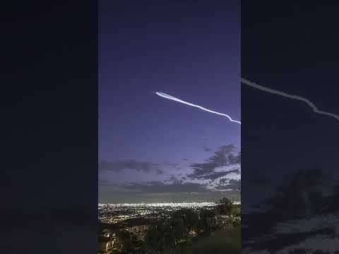
Thick fog swirled around Cape Canaveral Tuesday evening as SpaceX’s Falcon 9 rocket sliced through the gloom, leaving awed spectators in its wake. Rising from NASA’s Kennedy Space Center, the rocket carried a precious payload: two WorldView Legion satellites crafted by Maxar Technologies. These twin spacecraft expand the vision of Maxar Intelligence, adding to their impressive fleet already journeying through Earth’s orbit.
As the clock ticked to 6:13 p.m. EST, flames erupted at Launch Complex 39A. This was no ordinary launch—it marked SpaceX’s second Falcon 9 voyage of the day, underscoring their relentless cadence and precision. Less than eight minutes post-liftoff, the rocket’s first stage booster performed a flawless landing at Cape Canaveral’s Landing Zone 1. The seasoned booster, making its fourth flight, returned with the grace of a veteran, writing yet another page in SpaceX’s book of achievements.
High above Earth, the satellites embarked on their journey across mid-inclination orbits, enhancing Maxar’s unparalleled capacity for capturing stunningly detailed imagery at an astonishing 30 cm-class resolution. These satellites, the vanguard of Maxar’s technology, will traverse three million square kilometers of Earth daily, providing a mosaic of images sharper than any before available on the commercial market.
An impressive advancement, Maxar’s constellation now witnesses a leap in observational power, increasing its reach by 85% across Earth’s mid-latitudes. This expanded capacity promises insights into our changing planet, a testament to humanity’s ingenuity and drive to see Earth with unparalleled clarity. With eyes in the sky like these, perhaps our terrestrial challenges will seem just a bit less clouded.
SpaceX’s Daring Launch Transforms Earth Observation—What You Need to Know
How-To Steps & Life Hacks: Utilizing Satellite Imagery
To leverage satellite imagery effectively, consider these steps:
1. Identify Needs: Determine what information you require from the imagery—whether it’s urban development, agricultural planning, or environmental monitoring.
2. Choose the Right Platform: Services like Maxar offer diverse products; select the one tailored to your precision requirements and budget constraints.
3. Process and Analyze Data: Use software like QGIS or Esri’s ArcGIS to analyze and interpret satellite data, turning raw images into actionable insights.
Real-World Use Cases: Revolutionary Applications of Maxar Satellites
Maxar’s WorldView Legion satellites provide critical support in various fields:
– Disaster Response: High-resolution images speed up emergency response by assessing damage and planning recovery efforts.
– Urban Planning: Planners can track urban sprawl, infrastructure development, and changes in land use.
– Agricultural Optimization: Farmers can monitor crop health and optimize resource use, boosting yields and sustainability.
Market Forecasts & Industry Trends
The satellite imagery market is projected to grow exponentially, fueled by increasing demand for precise and up-to-date earth observation data. According to Allied Market Research, the satellite imaging market is expected to reach $10.6 billion by 2026, driven by advancements in imaging technologies and the proliferation of data-driven decision-making across multiple sectors.
Reviews & Comparisons
Reviews of Maxar’s imagery often highlight its superior resolution and accuracy. Compared to competitors like Planet Labs, Maxar provides higher detail levels, which is critical for advanced applications in defense, mining, and environmental monitoring.
Controversies & Limitations
While Maxar leads in image quality, privacy concerns remain a debate; the widespread availability of high-resolution images raises questions about surveillance and data use ethics. Furthermore, cloud cover and weather conditions can still obstruct image clarity, posing operational challenges despite technological advancements.
Features, Specs & Pricing
The WorldView Legion satellites boast an impressive 30 cm-class resolution, capturing expansive areas more swiftly than predecessors. Pricing varies based on data specifications and geographic coverage, often negotiated per corporate needs and contractual terms.
Security & Sustainability
Maxar implements strict security protocols to safeguard data, aligning with international standards. However, the environmental impact of satellite launches remains an industry concern, urging companies like SpaceX to explore eco-friendlier propulsion and fuel technologies.
Insights & Predictions
As satellite technology evolves, expect more frequent launches and enhanced imaging capabilities. Integration with artificial intelligence for automatic data analysis is likely to revolutionize Earth monitoring, driving the next wave of geospatial intelligence.
Tutorials & Compatibility
Maxar’s advanced data products are compatible with leading GIS software. Online tutorials on platforms such as YouTube and Maxar’s learning portals can help users master techniques in satellite image analysis and integration.
Pros & Cons Overview
Pros:
– High-resolution imagery allows for detailed analysis.
– Increased orbital frequencies enhance data freshness and coverage.
Cons:
– Cost may be prohibitive for smaller organizations.
– Weather interference can limit image usability.
Actionable Recommendations
1. Training: Invest in training for your team on how to use satellite imaging software effectively.
2. Strategic Implementation: Align image purchase and analysis with key business goals to maximize ROI.
3. Stay Updated: Follow Maxar and SpaceX updates to capitalize on new capabilities.
For more information on Maxar Technologies and SpaceX, visit their respective websites at Maxar and SpaceX.

")


")


